Day of Archaeology with the EAMENA project
Posted 29/7/2016
This blog by Rebecca Banks was originally posted on the Day of Archaeology.
Friday is usually the day when a traditional Monday to Friday 9–5 worker is closing off their week of work and getting ready for two days of luxurious weekend, right? Well, not so for this archaeologist. It is a busy time of year for us – it is summer and all the universities are on teaching breaks, but we are not using the opportunity to conduct fieldwork. We are busy at our computers getting ready for a conference: the opportunity to get together with other specialists, share ideas and research, and gain active feedback. Tomorrow I, along with two of my EAMENA colleagues (Michael Fradley and Andrea Zerbini) and our research collaborator Jérémie Schiettecatte (CNRS), are presenting at the Seminar for Arabian Studies at The British Museum.
We will tell you all about the conference in a later blog (on our EAMENA website where you can also find out more about our project) – for here and now for the Day of Archaeology I would like to give you a hint about all the work that is going into our presentation.

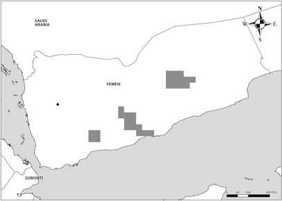
Map prepared by Andrea Zerbini.
We (the EAMENA project) have chosen three case study areas in different regions of Yemen to conduct a remote survey assessment of archaeological/heritage sites using publicly accessible satellite imagery. Ground surveys had been conducted in all of these areas and we are using the results of these studies as comparative data sets. Tomorrow we will be presenting our initial findings and what we can learn by comparing our data with the previous studies. This tests the validity of EAMENA’s remote approach for a regional assessment of Yemen’s archaeology, allows us to develop methods to improve our methodology, and demonstrates what benefits can be gained by a collaborative approach between remote and ground surveys.
Collaborating internationally on such a large study is a feat of communication – endless emails, shared online folders and documents, and video calls. Working in a team on our research has the benefit that we can all work to our strengths and complement each other’s approaches. The EAMENA team conducted the initial satellite imagery survey of more than 20,000 square kilometres of the landscape. Jérémie’s insight and familiarity with the archaeology of Yemen on the ground has been a huge benefit in understanding and processing the potential sites located by the remote survey. Andrea has been working on producing maps of the site distributions in ArcGIS, and these have been a revelation. They demonstrate visually the benefits of a regional approach to gathering data and quickly demonstrate differences in extents and concentrations of sites. This last week of finalising the presentation of our initial results into just 20 minutes has been intense. The difficulty today is making sure we are all on the same page when it comes time to present. I am constantly switching back between everyone’s notes on what we wish to cover during our presentation and making sure that the presentation comes together as a cohesive whole.
So why Yemen? The EAMENA project considered it appropriate to start investigating the archaeology of the region as a priority when reports began to indicate that incidental and possible targeted damage to archaeological and heritage sites was escalating in 2015 due to the civil war which had broken out in March. UNESCO called for an ‘Emergency Action Plan for the Safeguarding of Yemen’s Cultural Heritage’ in July 2015. The general unrest of the region has also contributed to a possible renewed wave of damage to local shrines. The vulnerability of the region at this point in time was compounded when two cyclones made landfall in late 2015 (for comparative satellite imagery of Cyclone Chapala’s impact see the NASA Earth Observatory website).
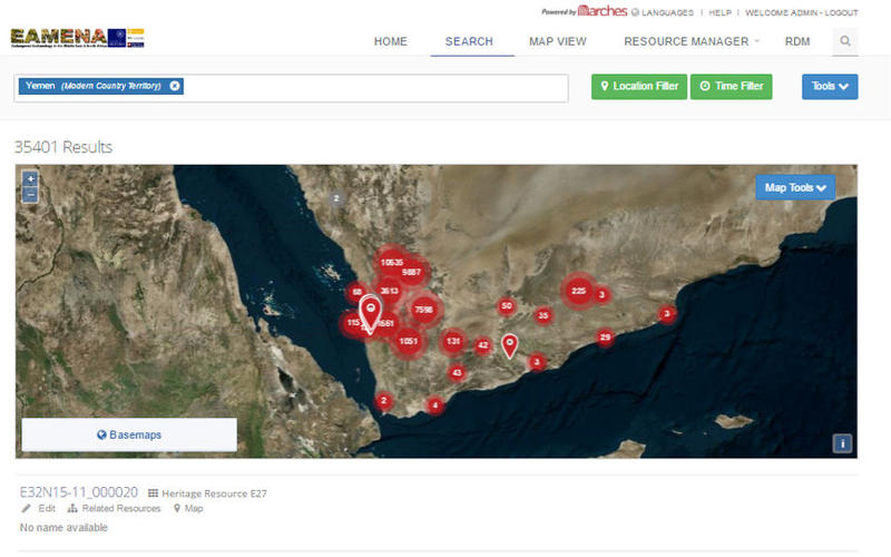
These disasters alerted us to the need for an assessment of the archaeology and heritage across the region as a whole, focusing not just on damage through conflict, but damage as the result of all activity. This could be used not only to inform current heritage priorities for local and international parties during this time of conflict, but those in the future, when Yemen will rebuild and development will occur with the potential for massive investment in infrastructure. Our first step was to start approaching researchers and specialists who have been working in Yemen, as well as the international (e.g. UNESCO) and national organisations (e.g. Yemen’s General Organisation for Antiquities and Museums (GOAM)) currently involved. Jérémie Schiettecatte was the first individual researcher to start an active collaboration with EAMENA. To date we have c. 35,500 sites for Yemen entered into our database which we have developed from the ARCHES platform. Another potential c. 8,600 sites will be added to these from the case studies we have most recently conducted.

A screenshot of the EAMENA ARCHES platform with distribution of currently entered sites for Yemen
Attending this conference is a way for us to present our preliminary results in a forum of specialists on the region. The feedback we receive will be integral in informing our research approach. It is also incredibly important for us to form networks and partnerships with the people and specialists of the regions we are investigating. Preparing the presentation material on top of our normal project work is demanding, but the dividends are extremely beneficial and well worth the effort.


