Endangered Archaeology in Gaza: issues accessing high-resolution satellite imagery
A recurring issue in monitoring the physical environment in Gaza and elsewhere in Palestine is the limited open-access high-resolution optical satellite imagery of these areas. Satellite imaging coverage of Palestine and Israel has faced restrictions since the initial development of the U.S. commercial satellite imagery industry in the 1990s, and while the work of EAMENA has been critical in lessening these constraints, they continue to limit the potential of monitoring via remote sensing. In this blog we will offer a brief summary of the current situation.
The legacy of the Kyl-Bingaman Amendment
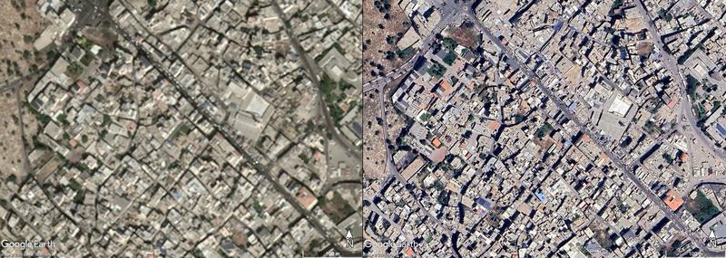
Following the end of the Cold War the U.S. in particular moved to develop a commercial industry using the satellite espionage technology that had been developed over previous decades. Under the Clinton administration this also meant the gradual declassification of the satellite imagery that had been collected since the 1960s, leading to a negative response in Israel where these releases were seen as a threat to national security. In particular, the release of imagery showing the Dimona nuclear facility in newspapers was highlighted as an issue, and subsequent lobbying of the U.S. would lead to limitations on the embryonic commercial satellite industry and on further releases of declassified imagery of Israel, commonly known as the Kyl-Bingaman Amendment (KBA). This set a limit to commercial and declassified imagery of Israel to 2m GSD, so that on a digital image a pixel roughly represents a 2m wide area, whereas by the 2000s commercial imagery for the rest of the world was reaching 0.5m GSD (Fig 1).

Fig. 1. A contrast of low- and high-resolution satellite images of the same area of Gaza City on Google Earth Pro, with a Mazar image limited by the KBA on the left from 29 September 2020 and an Airbus image on the right from 7 May 2022 (Source: Google Earth).
Although there was disquiet within the satellite industry at the time towards censorship, the impact would become more widely realised in the following years as the gap between the 2m GSD limit over Israel and the higher resolution of imagery elsewhere grew, and by the increasing availability of imagery via open-access-platforms such as Google Earth made these restrictions visible to a global audience.
At this point it is worth mentioning the elephant in the room that is that the KBA only referred to Israel, but that at least within the U.S. context this was implicitly taken to include occupied Palestine and the Golan Heights. The regulation also only applied in the U.S., but as the latter dominated the commercial satellite imagery industry up to the 2010s, these restrictions had a clear global impact on accessing imagery of Israel and Palestine. The key to lowering the restrictions lay in this last point as the KBA included a farsighted reform mechanism that meant the 2m GSD would be lowered if a non-U.S. entity began making imagery of a higher resolution available on the open market. It was this device that I explored with my late colleague Andrea Zerbini in 2017, quickly pulling together the evidence to demonstrate that outside the U.S. imagery at 0.5m GSD of Israel had been produced and made available by Airbus from at least 2012, and that from 2015 imagery at 0.4m GSD was being produced by Kompsat in South Korea via their K3A satellite.
Our work was published in the journal Space Policy in early 2018 (see ResearchGate for an open-access preprint), and we had also reached out to the U.S. regulator who maintained the KBA who we naively thought would be able to act on our clear evidence. In the U.S. the regulations were held by the Department of Commerce, but managed and monitored by the National Oceanic and Atmospheric Administration (NOAA), and who had responsibility for monitoring international market so that imagery of Israel produced or sold in the U.S. kept pace with the resolution of imagery abroad. In spite of our conclusive research that had already been published and shared with the NOAA, the latter would continue their own study and report the opposite in late 2018 that sub-2m GSD imagery was not available from non-U.S. companies, even though Airbus 0.5m GSD imagery had been used by UNITAR/UNOSAT as far back as the 2014 war in Gaza and published at the time in U.S. media such as the Wall Street Journal. Only following continued advocacy by EAMENA and our partners did the NOAA reassess the situation and report in 2020 that the limit should drop to 0.4m GSD, mirroring our own findings, although would make no public reference to our work, while they would also incorrectly claim that this was due to changes in the market since 2018 (the Kompsat K3A was launched in 2015, while Airbus Pleiades had been active since the early 2010s).
The NOAA methodology for assessing the global market was not published as part of their report findings, but it has been communicated that rather than just contact companies like Airbus (who are active in the U.S. market) to ask what resolution of imagery was being sold in Europe, the NOAA attempted to anonymously contact imagery retailers in the U.S. to identify what imagery resolution was available. As U.S. companies were controlled by the KBA limits this seems to have created a feedback loop where the NOAA would only be able to identify imagery at the 2m GSD or above in U.S. market because of the very restrictions they were tasked with investigating. This flawed process continues to impact on the KBA restrictions as the Airbus Pléiades Neo satellites were launched in 2021 and are capturing imagery of Israel and Palestine at 0.3m GSD. This should trigger a further drop of the KBA restrictions from 0.4m GSD to 0.3m GSD, but the NOAA have been unwilling to reopen their investigations on the current limit.
Accessing open-access high-resolution imagery of Gaza
For projects like EAMENA that cover such an extensive geographical region we rely heavily on being able to access high-resolution satellite imagery that are available through platforms such as Bing Maps and Apple Maps. The most useful open-access tool is still Google Earth Pro as it retains an archive of older imagery sometimes going back to the early 2000s that allow us to view archaeological sites on different images where different features may be better represented, but also allows us to monitor and chart changes over time. This will be key in our attempts to support heritage management in the region following the devastating bombardment and clearance of the region by the Israeli military.
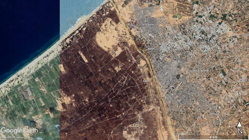
However, it is unlikely that imagery for the region will be updated in the near future, in part because there is convincing evidence that there is limited appetite to revise imagery on platforms like Google Earth. By way of example, on Google Earth Pro there are currently 93 scenes of high-resolution imagery dating back to 2004 covering the Old City area of Sana’a in Yemen, even though there is relatively limited interest in the country in the Western world. In contrast over the same period there are only 12 scenes covering Gaza City, of which only 4 are high-resolution that have been added since the lowering of restrictions in 2020, despite recent military conflicts and the focus of Western media and politics on this area. A similar contrast can be found with other cities in the region where Google Earth Pro has a significantly higher number of scenes available than for locations in Israel and Palestine. Even in smaller cities in the region there is significantly more imagery than for Gaza City, for example over Suez in Egypt where there are over 70 high-resolution scenes. In part the limited updates in the past may reflect the impact of the KBA when the limit was set at 2m GSD, so there was little reason to update blurred imagery of limited use. But even since the imagery limits were dropped in 2020 there have only been 4 image updates of Gaza, and no comparable ‘before and after’ images following events such as the 2021 Israeli war on Gaza comparable to the images available of Beirut from just before and after the Beirut port explosion in 2020. There have also been updates of imagery of parts of the northern Sinai in Egypt covering territory only c.4km from the south-western border of Gaza (Fig. 2).

Fig. 2. A composite satellite image of the south-western border of the Gaza Strip. The strip of green fields on the left of the image is dated to the 18 December 2023, while the area covering Gaza and the immediate border area has not been updated since 2022 (Source: Google Earth).
There is often a time lag when new imagery is updated on Google Earth and other platforms, and it is relatively opaque how and why these organisations update imagery. This does create an uncontrolled bias in our work as we remain relatively dependent on open-access imagery. At the time of writing, we can see almost up-to-date imagery can be added rapidly as in the wider region tiles of Airbus imagery from 7 December 2023 have been added to Google Earth Pro that cover parts of the Neom mega city development in north-western Saudi Arabia. Unfortunately, there is also evidence that the main providers of satellite imagery to Google Earth (Maxar and Airbus) have a self-imposed censorship on open publishing of imagery of Gaza since early November 2023, which may further slow or even completely prevent any imagery becoming freely available covering this period of bombardment of the Gaza Strip. As a result, we may have to look to purchase high-resolution imagery to undertake analysis.
We can see therefore not only do the KBA restrictions continue to impact the resolution of imagery covering the Gaza Strip in spite of the 2020 reforms, but further barriers appear to be in place in terms of imagery times being updated on platforms that are so often essential for so many forms of monitoring of conflict, human rights issues and other areas. Despite improvements since 2020 it is difficult to conclude that this will not improve soon at this critical time.


