Opening up historic aerial photograph datasets to support endangered heritage documentation in Egypt
Posted 27/2/2019
Dr Michael Fradley writes
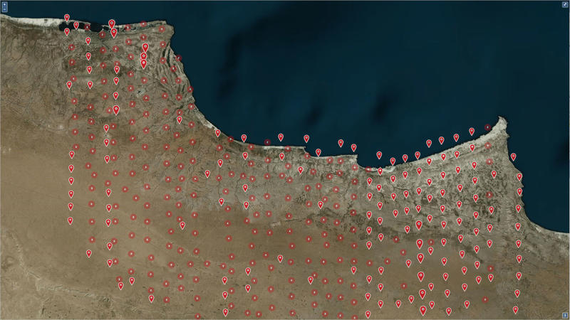
Support from Arcadia Fund has enabled the EAMENA project to add a collection of historic vertical aerial photographs from 1938 covering the town of Mersa Matruh and its environs on Egypt’s Mediterranean coastline to its online database (Figure 1). These photographs will allow EAMENA staff and other researchers to assess and document change and loss of heritage sites across this area over the last 80 years. Importantly, this photographic collection pre-dates the intensification of settlement, agriculture, and industrial activity in this region during the later 20th century, enabling an analysis of an earlier, relatively undeveloped landscape.
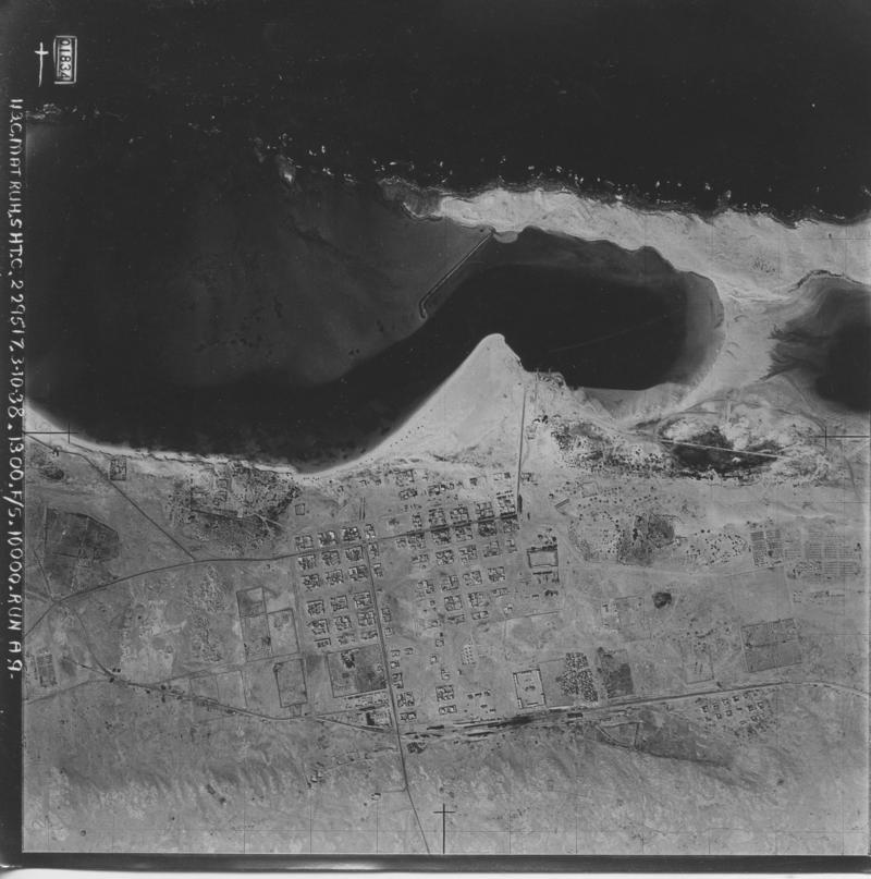
These photographs were taken by British military forces in 1938 in order to produce an updated topographical map of the region. This was necessitated by growing tensions with Italian forces on Egypt’s western border, as confrontation between European nations prepared for the Second World War. The topographical map would be constructed by taking overlapping vertical photographs (Figure 2), which could then be used to measure the topography of the landscape photogrammetrically. British forces used a relatively rudimentary slotted-template technique known as the ‘Arundel method’, which had been pioneered in the region from 1928–34, with surveys in Egypt, Yemen, Jordan, Iraq, and Kuwait. However, investment in photogrammetry and aerial photography was relatively limited by the British, and there were continued issues with the availability of appropriate cameras, aircraft, and trained air crew through the early years of the Second World War.
The survey was undertaken by ‘C Flight’ of 113 Squadron of the RAF, which had been based in Egypt since April 1938, although the original squadron had been based in Egypt and Palestine from 1917–19. In 1938 the squadron were flying Hawker Hind lighter bomber bi-planes, and undertook this survey mission from 23 September 1938 through to 1 November 1938. This mission may even have been the last large-scale photographic mapping mission undertaken using RAF bi-planes in the MENA region, as re-armament in the run-up to the Second World War saw the transfer to monoplanes, and 113 Squadron would convert to Bristol/Bisley Blenheim light bombers in June 1939. Mersa Matruh and the wider area was surveyed by air photography again from September to December of 1940 by 208 Army-Cooperation Squadron of the RAF for an updated 1:50,000 map series (MDR/122/55).
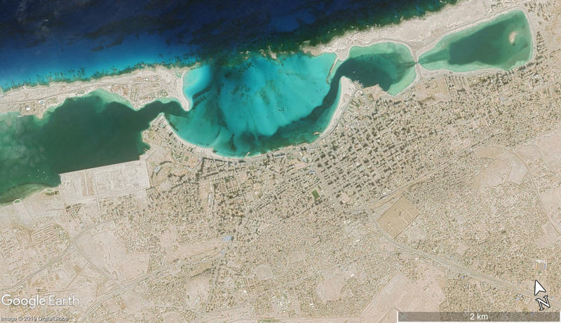
The landscape around Mersa Matruh has changed dramatically since the aerial mapping mission in 1938 (Figure 3). Expansion of settlement, coastal change and reclamation, agricultural intensification, road construction, quarries and mineral exploration and extraction have all had an impact, including on the inland desert areas covered by the survey. Although the region is less well-known than others on Egypt’s northern coast such as Alexandria, previous research has demonstrated notable occupation of this natural harbour (Hulin 2019). These 1938 aerial photographs, which mirror the vertical/near-vertical perspective of modern satellite imagery, will allow us to identify heritage sites that have not previously been documented, and understand change that have occurred at sites recorded by earlier ground surveys in this area.
In total, there are 1,014 photographs of the region that can be accessed, covering over 3,000 square kilometres; however this does not constitute the entire collection, which could not be scanned in full due to time restrictions that led to some overlapping images not being scanned. The scanned photographs have now been uploaded to the EAMENA database and can be accessed freely by registered users. This collection is of significant value to archaeologists, as well as any researchers interested in geographical change in this region, and will contribute significantly to documenting change in an endangered landscape.
References
Hulin, L. 2019. ‘Marsa Matruh Revisited: Modelling Interaction at a Late Bronze Age Harbour on the Egyptian Coast’ in A. Manzo, C. Zazzaro and D. J. de Falco (eds.) Stories of Globalisation: The Red Sea and the Persian Gulf from Late Prehistory to Early Modernity. Leiden: Brill.

Figure 2. An example of a 1938 aerial photograph, showing the town of Mersa Matruh (EAMENA photo reference: EGYPT_113C_MATRUH_A9_1834)

Figure 2. An example of a 1938 aerial photograph, showing the town of Mersa Matruh (EAMENA photo reference: EGYPT_113C_MATRUH_A9_1834)

Figure 3. A DigitalGlobe satellite image from 21 November 2018 showing the modern extent of Mersa Matruh and changes to its coastline (Map Data: Google, DigitalGlobe).


