Posted 15/10/2024
Bijan Rouhani, Bachaar Tarabay, Lynn Jabri, Mehraïl Saroufim write
This case study presents the results of a remote sensing survey to identify archaeological sites along a segment of the Afghanistan section of the TAPI (Turkmenistan-Afghanistan-Pakistan-India) gas pipeline project.

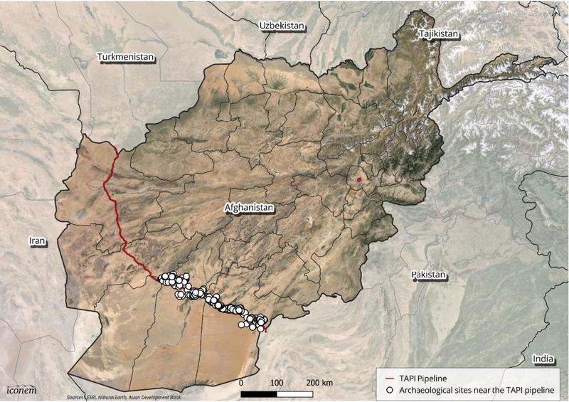
Assessed archaeological sites along the TAPI pipeline. Note sites are only shown on the pipeline segment studied.
Afghanistan's rich cultural heritage, spanning from prehistoric times to the modern state, has been significantly impacted by decades of conflict and instability, as well as development and natural factors. The TAPI gas pipeline project, spanning over 1,600 kilometres and supported by the Asian Development Bank, will pose additional risks to cultural heritage sites in Afghanistan due to its extensive construction and operational phases once construction begins.
To address these challenges, the Endangered Archaeology in the Middle East and North Africa (EAMENA) project, in collaboration with ICONEM, conducted a pilot study to document heritage sites along over 338 km of the pipeline corridor in Kandahar and Helmand provinces using remote sensing techniques. This initiative aims to provide an open-access dataset and establish a baseline for further remote monitoring of heritage resources in Afghanistan, adhering to the FAIR (Findability, Accessibility, Interoperability, Reusability) principles.
The pilot phase identified 433 heritage sites, including archaeological sites, historical settlements and structures, cemeteries, and traditional irrigation systems, in the surveyed section of the TAPI. These sites are located at varying distances from the pipeline. Among them, 75 sites are within a 500-meter buffer zone of the pipeline, indicating a first-degree threat from pipeline construction and associated activities. Among these sites, 37 qanat or kariz systems (subterranean irrigation channels) are at direct risk of being cut off, representing about 23% of the recorded qanats in the project area. In addition to their heritage values, these ancient but still functioning underground water supply systems are crucial for agriculture and the livelihoods of rural communities, necessitating special attention to potential damage during pipeline construction.
The dataset, maintained in the EAMENA database on the Arches platform, is accessible to Afghan heritage authorities, the TAPI project, the Environmental and Social Impact Assessment (ESIA) team, and interested researchers and heritage professionals. The data collection and analysis followed EAMENA's methodology for documenting endangered archaeological resources, utilising free remote sensing data from Google Earth and other sources.
This report aims to assist in heritage preservation, mitigate development risks, and raise awareness about Afghanistan's cultural heritage and its threats. The initiative also seeks to establish a methodology for Afghan researchers and heritage professionals interested in documenting, monitoring, and managing cultural heritage resources using open-access satellite imagery and open-source software.
Ultimately, the project underscores the need for continued efforts to protect and preserve Afghanistan's invaluable cultural heritage in the face of ongoing development and natural challenges.
To access and download the full report, please visit: https://zenodo.org/records/13912379
To access and download the heritage dataset, please visit: https://zenodo.org/records/12772271