Lebanon’s Heritage at Risk: Part 2
Posted 30/3/2017
Jennie Bradbury continues her description of Lebanon by considering survey work
Numerous surveys have been carried out across Northern Lebanon, from the Akkar plain in the north, to Copeland and Wescombe’s work across Lebanon as a whole (e.g. Bartl 1998; Copeland and Wescombe 1966; Garrard et al. 2004; Thalmann 2007). The chronological focus of these works, however, was often restricted, focusing on a specific period, for example the Palaeolithic through to the Neolithic periods. More recently, excavations and detailed site-based surveys have been carried out at Anfeh (Panayot Haroun 2015) and Kfar’abida (Genz 2014). These studies revealed important information about ancient occupation and activity in these regions and, in the case of Anfeh, also had a cultural heritage focus through work researching 20th century salt pan industries. Despite these excellent studies, activity and occupation in the wider coastal region is still poorly understood.
With this in mind, in 2016, thanks to a generous grant from the Council for British Research in the Levant (CBRL), and working in the collaboration with the American University of Beirut (AUB) and the Direction Générale des Antiquités du Liban (DGA), we initiated the Kūbbā Coastal Survey. The aims of this project are to use remote sensing techniques, alongside field survey, to build a baseline of archaeological data from which to assess the heritage resources of this region, ranging in date from the Palaeolithic to the early 20th century CE.
Fieldwork in 2016 was carried out over a period of three weeks and focused on the area surrounding Batrun and Kūbbā, both modern settlements with evidence for occupation extending back at least into the Bronze Age. More limited fieldwork was carried out in the modern villages on the Shikā Plateau. During the season the team identified and recorded over 100 archaeological sites, features, and field scatters. These included material dating from the Palaeolithic through to the early 20th century CE, including sites such as abandoned farmsteads and houses, material scatters, water channels and mills.
Prior to our ground survey in the region, analyses conducted using Google Earth, Corona satellite imagery, and 1:20,000 map data had already pointed towards the existence of a number of potential archaeological sites and features (see Part 1 of this blog), such as cave systems, abandoned settlements, and tombs. The majority of these sites were subsequently visited and recorded in the field, demonstrating the potential of a combined remote sensing, cartographic, and field survey approach. The ceramic material collected from the survey region was, overwhelmingly, Mamluk (c.1289–1518 CE) through Ottoman (c.1518–1918 CE) in date, although significant assemblages of Classical material (c.300 BCE–640 CE) were also collected. Several locales also revealed dense scatters of earlier material (Neolithic to Bronze Age), including stone tools, suggesting that activity and/or settlement was not just confined to tell sites (settlement mounds) in the region.
Some of the most exciting findings of the 2016 season include the rock-cut tombs from the slopes of the Shikā Plateau, the mills documented from the Nahr al Jawz valley, and a number of abandoned farmsteads, likely to be Ottoman in date. In addition, our work began to trace and record a network of water channels which criss-cross the survey area and feed the garden areas of Batrun, as well as the agricultural fields of the Nahr al Jawz valley and Kūbbā. These long, stone-built and concrete-lined water channels run for kilometres through the landscape, and in their present incarnation, appear to date to the French Mandate period. However, detailed study and mapping has demonstrated the existence of several phases of construction, suggesting that these networks of water channels date back at least to the Ottoman period, and may have even earlier phases associated with them. This is one area of investigation that we are keen to pursue further in future seasons.
One of the principle aims of the project was also to build up a record of the types of disturbances and threats affecting archaeological sites and features across the region. We were able to test some of the assessments we had made from satellite imagery analysis in the field, and using the EAMENA database these observations can be furthered analysed and queried. For example, combining field and remote sensing analysis, 226 potential archaeological sites have been identified from an area of roughly 70 km² north and east of Batrun. Of these, 190 (84%) have been visibly disturbed in some way, whether by natural or anthropogenic causes.
Out of the 215 sites where it was possible to assess condition state, less than 10% were recorded as in very poor condition, or have been destroyed (it was not possible to give an assessment for all sites for various reasons, including, for example, poor image resolution). Conversely, over 70% of sites are in a relatively good condition, despite having been disturbed in some way. Although these are encouraging statistics clearly continuous monitoring in the future is required; based on this analysis, over 80% of possible archaeological sites are currently threatened by natural and/or anthropogenic factors. The origins of these threats derive from causes as varied as construction, ploughing, greenhouse construction and, as already discussed in Part 1, natural vegetation growth.
Plans are already underway for a second season of fieldwork in this region in 2017–18. Meanwhile, the EAMENA team have been busy trying to collate existing published data covering the rest of Lebanon, to which we will return in Part 3 of this blog.
Many thanks go to the survey team Rebecca Banks, Daniel Hoffman, Mahmoud Mardini, Azadeh Vafadari, and Berj Wannessian, without whom the Kūbbā Coastal Survey would not have been possible. Immense thanks also go to the two pottery specialists on the project, Stephen McPhillips and Melissa Kennedy. Fieldwork in 2016 was supported by a grant from the Council for British Research in the Levant and we are indebted to their support. Special thanks also go to the staff of AUB and the Direction Générale des Antiquités du Liban.
Bartl, K. 1998. Archaeological Surface Investigations in the Plain of Akkar/Northern Lebanon. Preliminary Results. Bulletin d’archéologie et d’architecture libanaises 3: 169–179
Copeland, L. and Wescombe, P. 1966. Inventory of Stone-Age Sites in Lebanon, Part 2: North, South and East-Central Lebanon. Mélanges de l’Université Saint-Joseph 42: 1–174
Garrard, A., Yazbeck, C., Bates, M., and Seif, A. 2004. Qadisha Valley Prehistory Project (Northern Lebanon) Results of 2003 Survey Season. Bulletin d’archéologie et d’architecture libanaises 8: 5–46
Genz, H. 2014. Excavations at Tell Fadous-Kfarabida 2004–2011: an Early and Middle Bronze Age Site on the Lebanese Coast. In F. Höflmmayer and R. Eichmann (eds), Egypt and the Southern Levant in the Early Bronze Age. Orient Archäologie 31. Rahden/Westf, Verlag Marie Leidforf GmbG: 69–91.
Panayot Haroun, N. 2015. Anfeh Unveiled: Historical Background, Ongoing Research, and Future Prospects. Journal of Eastern Mediterranean Archaeology & Heritage Studies 3(4): 396–415
Thalmann, J.-P. 2007. Settlement Patterns and Agriculture in the Akkar Plain during the Late Early and Early Middle Bronze Ages. In D. Morandi Bonacossi (ed.), Urban and natural landscapes of an ancient Syrian capital: settlement and environment at Tell Mishrifeh/Qatna and in central-western Syria. Studi archeologici su Qatna 1. Udine, Forum: 219–232.
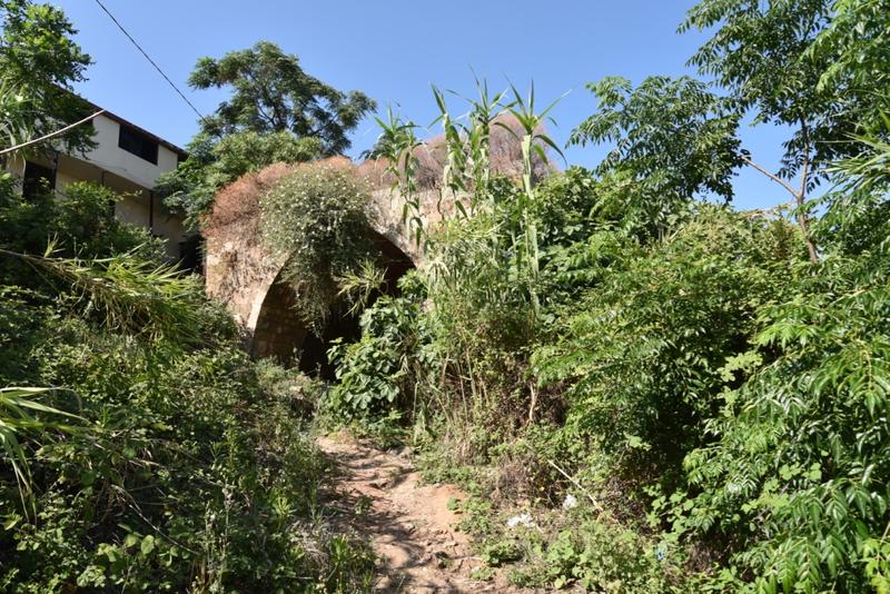
Mill in Nahr al Jawz Valley
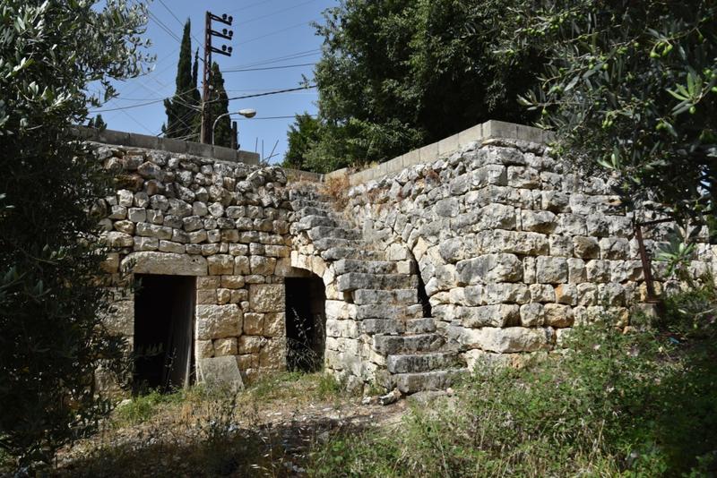
Abandoned house and bakery (?)
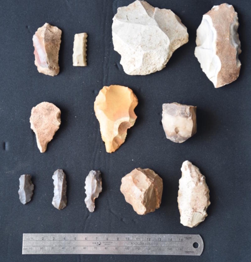
Stone tools collected from the survey area
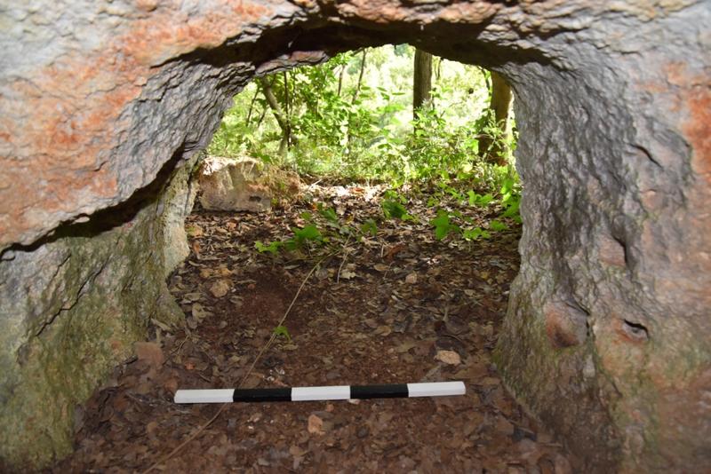
Rock cut tomb
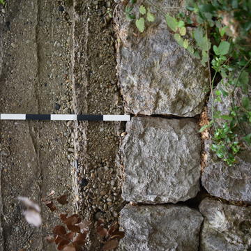
Water channel
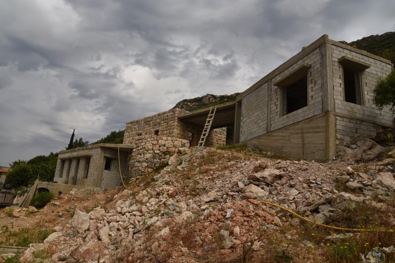
Construction of modern houses alongside older buildings


