Which visitor or town? The ‘Great Transfiguration’ of Sinai’s endangered cultural mountain landscape
اى زائر او مدينة؟ "التجلى الأعظم" بالنطاقات الجبلية الثقافية المعرضة للخطر بسيناء
Sinai, with its beautiful kaleidoscope of landscapes was a once tranquil area, whose natural assets are now beacons for developers to lure tourists. It is now at risk of growing into a lodestone overrun by unprecedented and unsustainable numbers of visitors.
Sinai’s transitional geography is a multifaceted complex dimension — compounded by a country pushing for gigantic new projects in a short-to medium-term period, aiming for a high return on investment. The central government of Egypt (Ministry of Planning and Economic Development), has initiated the ‘Great Transfiguration’ project which is yet another top-down ‘tourism development project’. Such projects depend on a group of consultants and/or sub-contractors to work in collaboration with the South Sinai Governorate and the Ministry of Environment (Nature Conservation Sector), in one of Egypt’s (and the Middle East’s) outstanding cultural landscapes - at the epicentre of which is a UNESCO World Heritage Site: the vicinity of Mount Sinai and Saint Catherine's Monastery in the High Mountains Region of the peninsula.
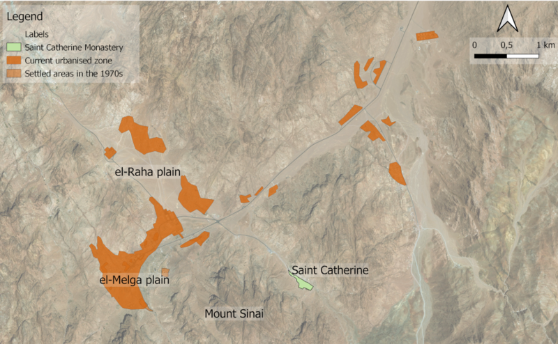
Map 1 The present-day St Catherine area. Background imagery © Bing 2021
Sinai is a desert of classical cultural landscapes which have been written about, painted and photographed, and mapped. Pilgrims, travellers, scholars and more recently tourists traversed the land to the traditional location of Mount Sinai, Gebel Musa, since at least the 4th century CE. The economy of the town of Saint Catherine has relied on eco-cultural tourism since 1980s through family-based businesses, or one-day mass tourism to Mount Sinai from the resorts on the Gulf of Aqaba, operated by tourism companies and led by local Bedouin guides and cameleers from the Gebaliya tribe.
The new project, by name and messaging, is aimed at ‘The Pilgrim’ or in a contemporary sense ‘The Eco-cultural Tourist’. This short article is not talking about a marketing campaign, however, but rather, a high-density construction project which involves high concentration of buildings in the town, and extends to el-Raha plain, one of the most classical and well-documented scenic views in the peninsula. It was the pilgrim’s natural and historic gateway to the Monastery of Saint Catherine and Mount Sinai.
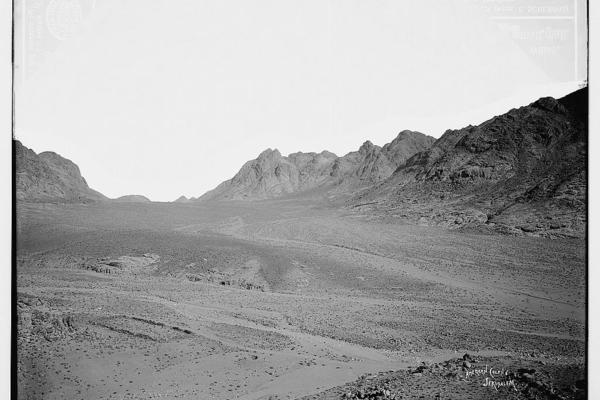
El-Raha plan in the early 20th century https://www.loc.gov/item/2019698523/ |
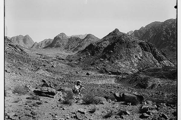
Raha plan in the early 20th century https://www.loc.gov/pictures/item/2019698084/ |
The above opens a controversial question about which ‘Alpine’ town the developers imagined in their design?! A leisure town for mass tourism with government or external investment to construct high concentrations of buildings including chalets (accommodation and service facilities), plus the possible re-emergence of the 1980s cable cars argument in the future, or a cluster of eco-cultural tourism facilities distributed between existing localities and suited to the declared target-visitor?
The first type of tourism development model – and unfortunately, the model pursued (in terms of context) by the current central/regional authorities or developers – has a high negative impact on the surrounding protected cultural landscape, while the second will develop a large number of localities, create direct job opportunities in-situ, reduce the environmental impact through distributing the flow of visitors without decreasing the target-numbers or return-on-investment, establish multiple entry points across the mountain range which will have a positive effect on the overall visitor experience, and protect Sinai’s endangered cultural landscape.
Such a modest impact—compared to the proposed ‘Great Transfiguration’ project—has been well-documented since the transformation of the traditional Bedouin encampment in el-Melga plain to what later became the present and only mountain (heritage) town in Egypt: the town of Saint Catherine. It was part of an urbanisation process that took place from the 1980s, not top-down urban planning, but which still exerted a considerable pressure on ground water resources and the vegetation in the town and the surrounding cultural landscape, with a relatively small population engaged in the existing tourism development model described above, compared to the current project under construction.
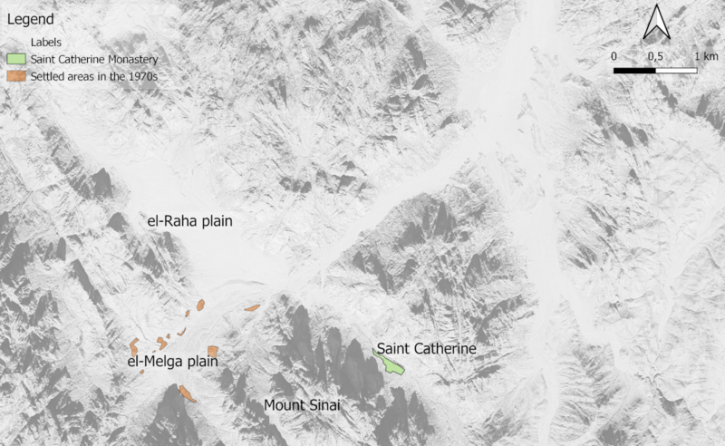
Map 2 The mountain landscape near the St Catherine Monastery in 1974. Background imagery KH-9 high resolution satellite imagery available through the USGS |
|||||
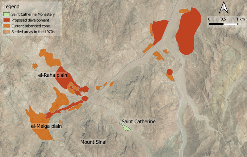
Map 3 The 'Great Transfiguration' of South Sinai, showing the urbanisation of the town of Saint Catherine and newly constructed visitor accommodation. The new constructions will completely transform the landscape. Background imagery © Bing 2021 |
Despite the importance of the interest of the central government in the town, the faulty dimension in the execution of the ‘Great Transfiguration’ project is the limited consideration of the totality of the economic value of the cultural landscape. There is a substantial value in protecting Sinai’s classical scenic views associated with ‘The Pilgrim’, whereas the construction (hotels and real-estate) is only one component of landscape value (i.e., financial value), which will have an adverse impact on the town of Saint Catherine in the medium and long term.
Re-thinking ‘which - visitor or town?’ is the timely answer to the protection of Sinai’s endangered mountain cultural landscape.
Further reading
Shams, A. (2011). Eight years wandering in the High Mountains of Sinai Peninsula: a tale of two maps. Cairo: Sinai Peninsula Research
Shams, A., and Ten Harkel, L. (2019). The SinaiArchaeoWater Project (SAW), EAMENA blog.
اى زائر او مدينة؟ "التجلى الأعظم" بالنطاقات الجبلية الثقافية المعرضة للخطر بسيناء
١٧ ديسمبر ٢٠٢١ احمد شمس (جامعة درهام)، ليتي تن هاركيل (جامعة أكسفورد)
سيناء، بمشاهدها الرائعة من المناظر الطبيعية و التى كانت منطقة هادئة ذات يوم، أصبحت أصولها الطبيعية فى الوقت الحالى منارات للمطورين لجذب السائحين. المنطقة الجبلية بشبه الجزيرة معرضة لخطر اجتياحها باعداد كبيرة غير مسبوقة و غير مستدامة من الزائرين.
تعد الجغرافيا الانتقالية لسيناء معقدة و متعددة الأوجه، حيث تتضاعف تلك الأوجه فى بلد يدفع باتجاه مشاريع جديدة عملاقة خلال فترة زمنية من قصيرة إلى متوسطة، و تهدف لتحقيق عائد مرتفع على الاستثمار. بادرت الحكومة المركزية بالقاهرة (وزارة التخطيط والتنمية الاقتصادية) بمشروع "التجلى الأعظم"، و الذى يعتبر مشروع اخر مركزى (مشروع تنمية سياحية). يعتمد تنفيذ المشاريع المماثلة على التعاون بين مجموعة من الاستشاريين و شركات المقاولات من جهة، و محافظة جنوب سيناء و وزارة البيئة (قطاع المحميات الطبيعية) من جهة اخرى، فى واحدة من اكثر النطاقات الجبلية الثقافية تميزاً فى مصر و الشرق الأوسط ، و فى مركزها موقع لليونسكو للتراث الثقافى العالمى: نطاق جبل سيناء (جبل موسى) و دير سانت كاترين فى منطقة الجبال العالية بشبه الجزيرة.

Bing 2021© خريطة (١) منطقة سانت كاترين فى الوقت الحاضر
تعد صحراء سيناء منطقة غنية بنطاقات ثقافية كلاسيكية، تم الكتابة عنها، و رسمها و تصويرها فوتوغرافيآ، و رسم خرائط لها. الحجاج و الرحالة و العلماء و السائحون فى الآونة الأخيرة، كلهم عبروا ارض سيناء، منذ القرن الرابع الميلادى على اقل تقدير، بهدف الوصول للموقع التقليدى المتعارف عليه لجبل سيناء (جبل موسى). اعتمد اقتصاد مدينة سانت كاترين منذ ثمانينات القرن الماضى على السياحة البيئية الثقافية من خلال الاعمال التجارية للعائلات المحلية، او على تدفق اعداد كبيرة من سائحى اليوم الواحد و القادمون من المنتجعات الشاطئية على خليج العقبة لزيارة جبل موسى. تدفق تلك الأعداد لزيارة جبل موسى يتم من خلال منظمي الرحلات السياحية و يقوم الأَدِلاَّء و الجمالة من البدو المحليين من قبيلة الجبالية بارشاد السائحين على جبل موسى.
طبقآ للأسم و التسويق الخاص بالمشروع، يهدف المشروع الجديد إلى جذب الزائر "الدينى او الحاج" ، او فى الوقت المعاصر "السائح الثقافى البيئى".هذه المقالة القصيرة لاتهدف للحديث عن الحملة التسويقية للمشروع، بل تتحدث عن مشروع كثيف الإنشاءات و الذى يتضمن بناء اعداد كبيرة و مركزة من الابنية فى المدينة، و تمتد الاعمال إلى سهل الراحة، حيث يعد السهل احد اكثر المناظر الكلاسيكية الخلابة التى تم توثيقها فى شبه الجزيرة. حيث كان يعد سهل الراحة بوابة الحجاج التاريخية و الطبيعية لدير سانت كاترين و جبل سيناء.

|

|
شكل (١) سهل الراحة فى اوائل القرن العشرين الميلادى. (https://www.loc.gov/item/2019698523/) (https://www.loc.gov/pictures/item/2019698084/)
ما سبق يطرح سؤالاً مثيراً للجدل حول أي مدينة جبلية (او فى جبال الالب!) تخيلها المطورون في تصميمهم للمشروع الجديد؟ (أ) انشاء مدينة عطلات تتناسب مع تدفقات اعداد كبيرة من السائحين بواسطة استثمارات حكومية او خارجية لانشاء اعداد كبيرة و مركزة من الابنية، متضمنة شاليهات (و منشآت خدمية و فندقية)، بالاضافة لاحتمالية عودة النقاش الخاص بالتلفريك العائد لثمانينات القرن الماضى من جهة، (ب) او بناء مجموعة من المنشآت السياحة البيئية الثقافية الموزعة على القرى و المستقرات المحلية و الملائمة للزائر المستهدف المعلن عنه؟
النموذج الأول للتنمية السياحية، الجدلى، هو النموذج الحالى (من حيث المضمون) قيد الانشاء بواسطة المطورين او الحكومة المركزية (و المحلية) و الذى له بالغ التأثير على النطاقات الجبلية الثقافية المحيطة، مع انه كان يتوقع من اتباع النموذج الثانى (١) تطوير عدد كبير من القرى و المستقرات المحلية، (٢) خلق فرص عمل مباشرة فى تلك المستقرات، (٣) تقليل الاثر البيئى من خلال توزيع تدفق السائحين على المنطقة الجبلية جغرافيآ بشكل متوازن، بدون خفض اعداد السائحين المستهدفة او العائد على الاستثمار، (٤) و من خلال تخطيط عدة نقاط دخول للنطاق الجبلى، (٥) و الذى سيكون له التأثير الايجابى على تجربة الزائر و حماية النطاقات الجبلية الثقافية المعرضة للخطر فى سيناء.
يعتبر النموذج الثانى ذات تأثير معتدل مقارنة بالتصور الحالى لمشروع "التجلى الأعظم"، و قد تم توثيق تأثير مماثل معتدل نسبياً منذ ان تحول المستقر التقليدى للبدو بسهل الملقاة إلى ما اصبح فيما بعد المدينة الجبلية و الوحيدة التراثية فى مصر: مدينة سانت كاترين. المدينة كانت جزء من عملية توسع عمرانى، و ليس تخطيط عمرانى مركزى، و على الرغم من ذلك تسبب ذلك التوسع فى ضغوط على موارد المياه الجوفية و الغطاء النباتى فى المدينة و النطاقات الجبلية الثقافية المحيطة. تم هذا من خلال تعداد سكانى صغير نسبياً من السكان المحليين المنخرطيين فى النموذج القائم للتنمية السياحية، مقارنة بالمشروع قيد التنفيذ حاليا.

|
|
خريطة (٢) النطاق الجبلى المحيط بدير سانت كاترين عام ١٩٧٤م. صورة الخلفية KH-9 عالية الدقة و المتاحة من خلال USGS. |

|
|
خريطة (٣) "التجلى الأعظم" فى جنوب سيناء، موضحة التوسع العمرانى لمدينة سانت كاترين و منشئات اقامة الزائرين الجديدة. الاعمال الانشائية الجديدة ستغير المشهد العام بالكامل. صورة الخلفية Bing 2021© |
على الرغم من أهمية اهتمام الحكومة المركزية بالمدينة، البعد الخاطئ فى مشروع "التجلى الأعظم" يتمثل فى محدودية الاخذ فى الاعتبار المفهوم الشامل للقيمة الاقتصادية للنطاق الجبلى الثقافى. توجد قيمة كبيرة فى حماية المناظر الطبيعية الكلاسيكية فى سيناء و المتعلقة بالزائر "الدينى او الحاج"، حيث اعمال الانشاء (الفنادق و العقارات) هى بعد واحد فقط من ابعاد متعددة للقيمة المالية للنطاقات الجبلية الثقافية، حيث سيكون لتلك الاعمال بالغ التأثير على المدى المتوسط و الطويل.
اعادة التفكير فى اى زائر او مدينة؟ هى الاجابة لحماية النطاقات الجبلية الثقافية المعرضة للخطر فى سيناء.


